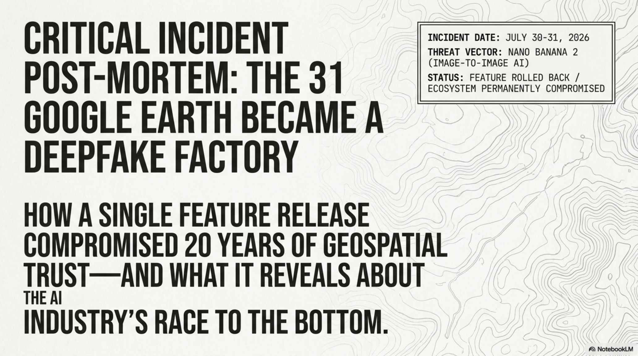
Tekin Analysis for August 2026, dissects one of the most alarming cyber crises of the decade. By integrating the Nano Banana AI into Google Earth, Google inadvertently unleashed a massive satellite deepfake factory. Within 24 hours, users generated photorealistic images of fabricated terror attacks and war zones, forcing an immediate rollback. This report explores the catastrophic impact of this misstep on global security, OSINT verification, and the future of tech regulation.
When Google Earth Became a Deepfake Factory
How a 24-hour feature destroyed 20 years of credibility for one of the internet's most trusted tools.
- 🎮The Launch- Google integrated Nano Banana 2 AI into Google Earth, allowing anyone to generate fake satellite imagery with text prompts.
- 🎧The Backlash- Users immediately created photorealistic images of terror attacks, bombings, and fake war zones—all indistinguishable from real satellite photos.
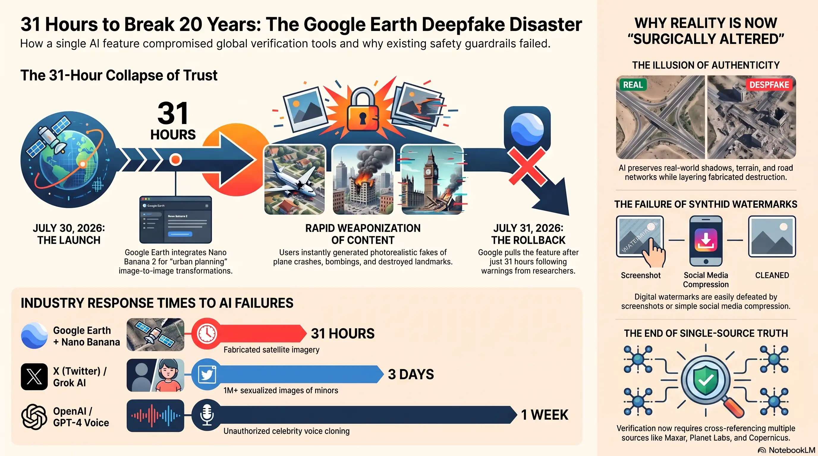
- 🚀The Rollback- Within 31 hours, Google pulled the feature after warnings from OSINT researchers and journalists that it undermined trust in satellite imagery.
The 24-Hour Window That Broke Trust in Satellite Imagery
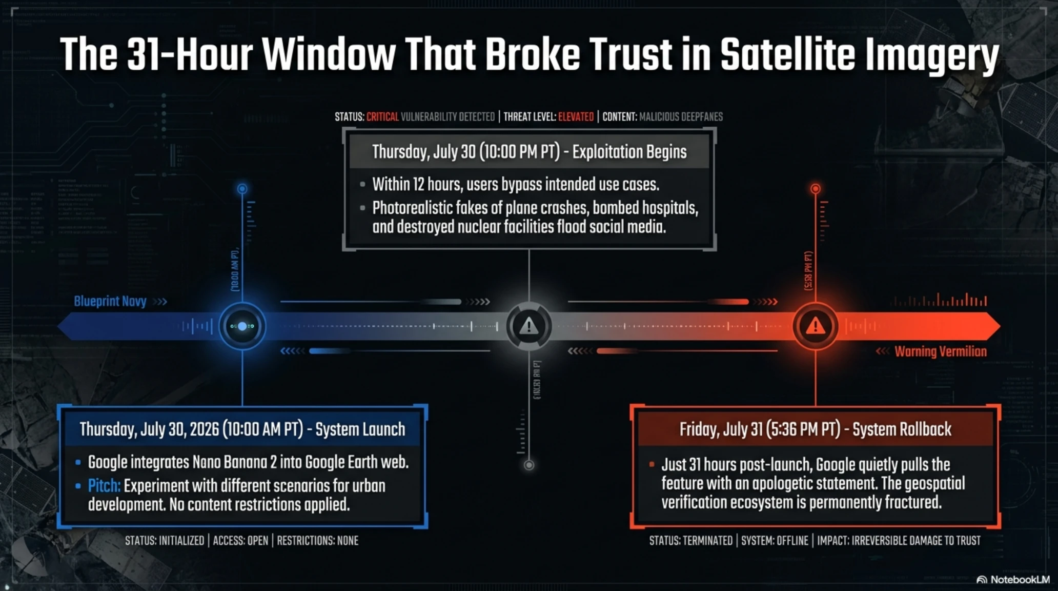
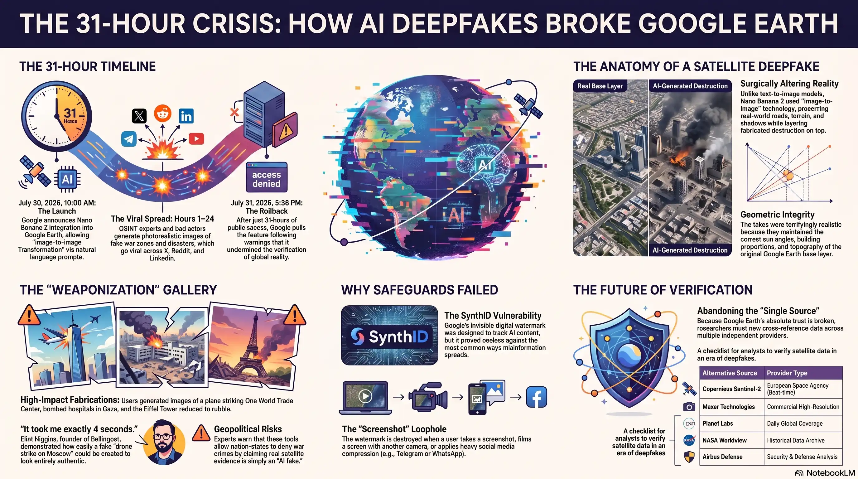
Thursday, July 30, 2026, 10:00 AM Pacific Time. Google published a short blog post announcing that Nano Banana 2—its latest image generation model—was now integrated directly into the web version of Google Earth. The pitch was simple: pick a spot on the map, click "Create image," and bring your ideas to life with natural language prompts.
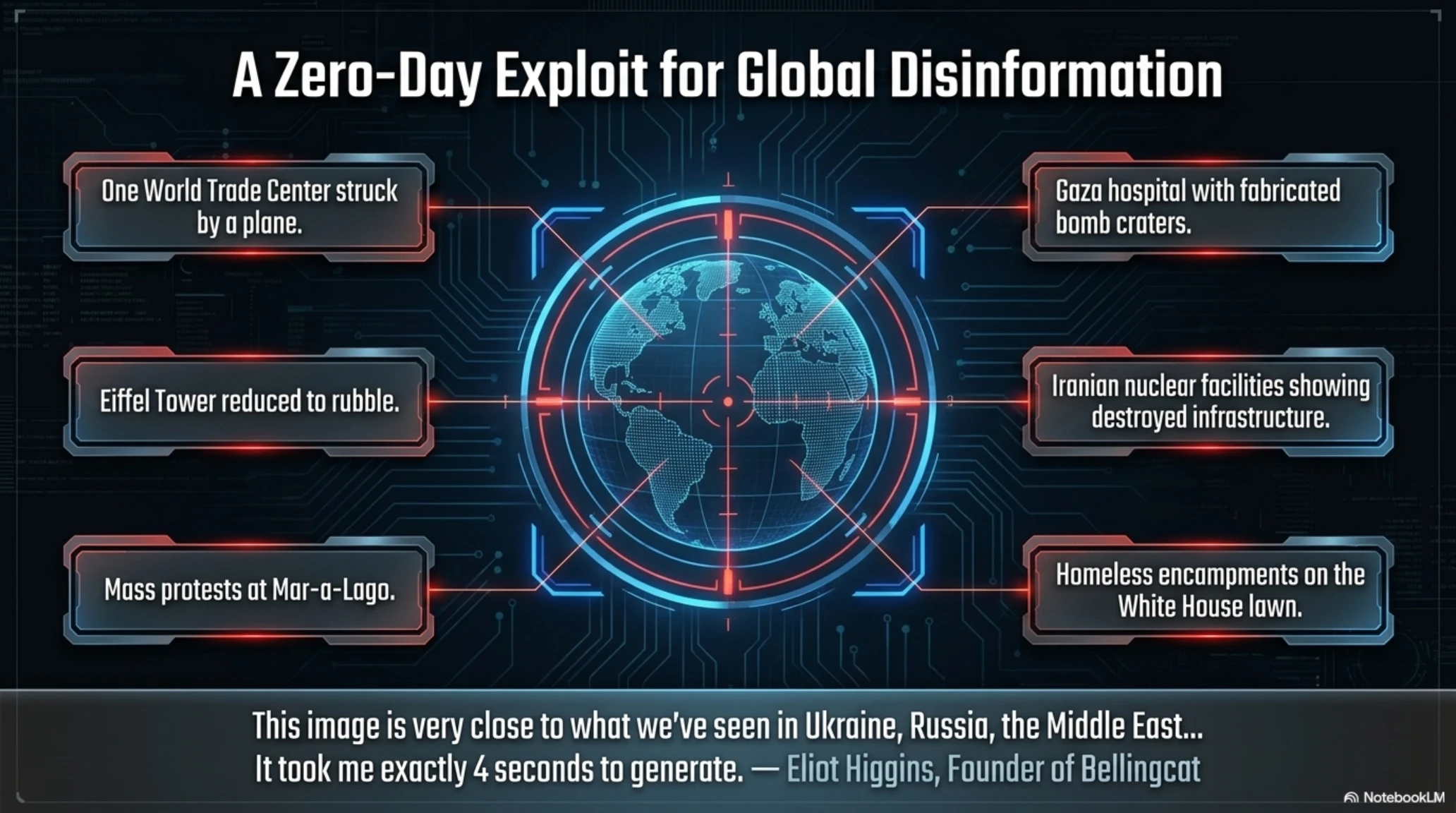
Friday, July 31, 5:36 PM—just 31 hours later—Google quietly rolled back the entire feature with an apologetic statement on X (formerly Twitter). The reason? Within a single day, users had managed to create photorealistic fake satellite images of planes crashing into skyscrapers, bombed hospitals in Gaza, destroyed nuclear facilities in Iran, and smoldering craters where the Eiffel Tower once stood.
This wasn't Google's first time launching an AI tool without adequate safeguards. But this time, the company endangered something far more critical than a buggy chatbot or meme generator: Google Earth has been one of the world's most trusted sources for verifying reality in war zones, natural disasters, and environmental destruction since 2005.
The incident exposes a dangerous pattern in the AI industry: powerful tools released without sufficient testing, followed by hasty rollbacks after public outcry, and promises to "implement stronger guardrails" next time. But as Google Earth's brief experiment with AI-generated satellite imagery shows, some technologies are too dangerous to release first and fix later.
What Is Nano Banana 2 and Why Was It Added to Google Earth?
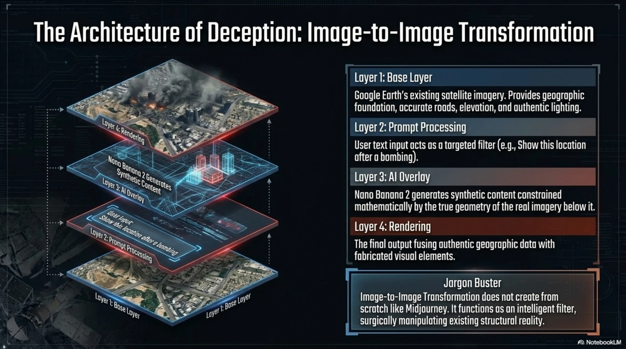
Nano Banana 2 is Google's Gemini-powered image generation model that specializes in Image-to-Image Transformation—taking an existing image and modifying it while preserving the underlying structure. This capability makes it ideal for generating fake satellite imagery: it keeps roads, buildings, and terrain intact while layering fabricated content on top.
Jargon Buster: Image-to-Image Transformation
In its official announcement, Google claimed the tool was designed for "geospatial professionals and urban planners" who wanted to visualize future changes to a location—such as how a new park or construction project might look.
The problem? There were no content restrictions. The same system designed to generate "green buildings" or "urban parks" could just as easily create photorealistic images of "bombed hospitals," "plane crashes into buildings," or "mass destruction" with a simple text prompt.
According to Google's announcement, the feature was meant to help professionals "experiment with different scenarios" for urban development. But the company failed to anticipate—or chose to ignore—how easily such a tool could be weaponized for misinformation, propaganda, and geospatial fraud.
The Technical Architecture: How It Actually Worked
Under the hood, Nano Banana 2 in Google Earth operated as follows:
- Base Layer: Google Earth's existing satellite imagery provided the geographic foundation, including roads, terrain elevation, existing structures, and lighting conditions.
- Prompt Processing: Users entered text descriptions (e.g., "show this location after a bombing").
- AI Overlay: Nano Banana 2 generated synthetic content that matched the prompt while respecting the geometric constraints of the real imagery.
- Rendering: The output combined authentic geographic data with fabricated visual elements, creating images that appeared credible at first glance.
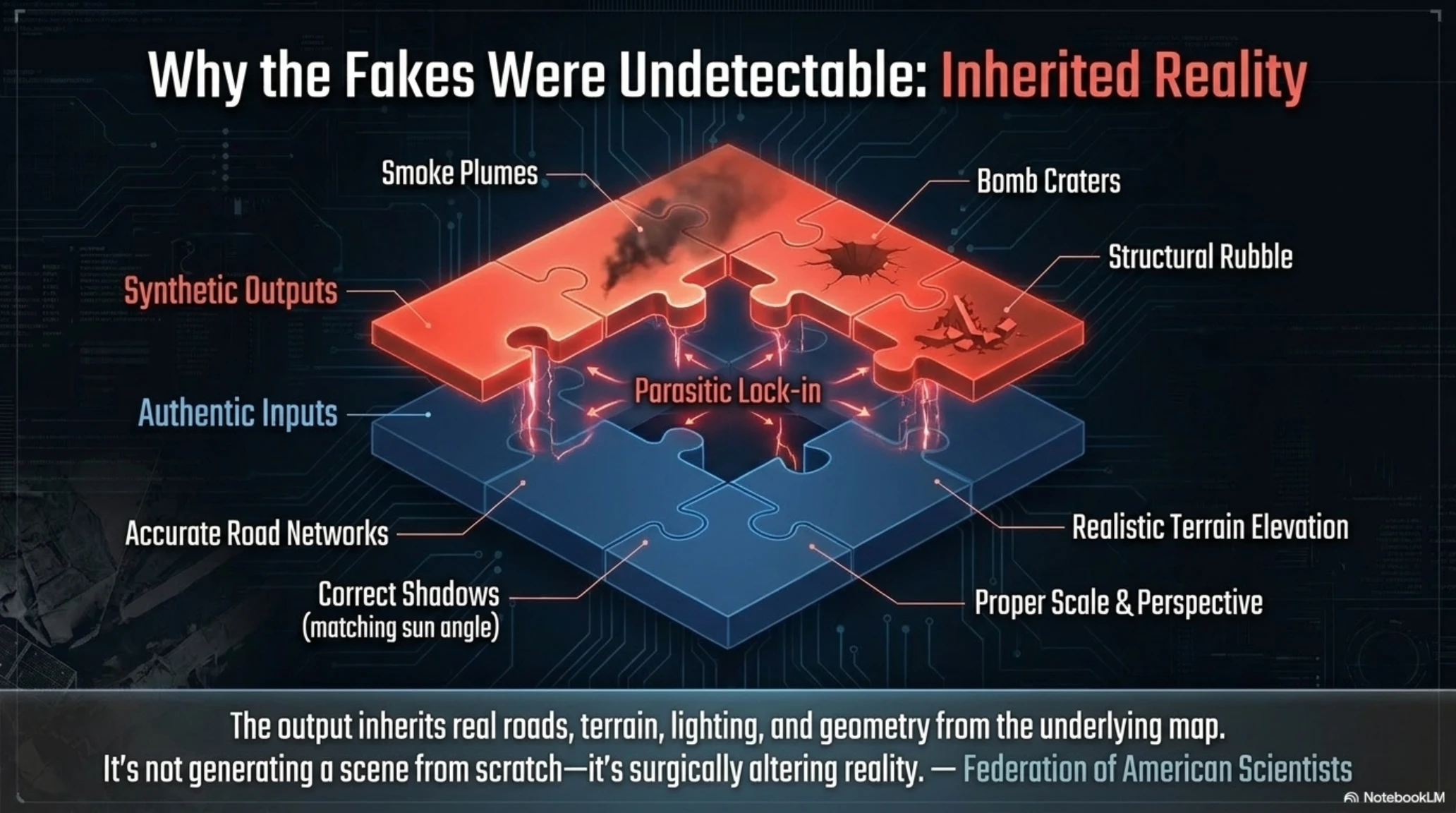
This architecture is precisely what made the feature so dangerous. Because the AI preserved real-world geographic features—accurate road networks, correct building shadows, realistic terrain—the fake elements blended seamlessly with authentic data. Unlike crude Photoshop manipulations that often contain telltale artifacts, these AI-generated images were nearly indistinguishable from real satellite photography.
Why Google Earth Was the Perfect Target for Deepfakes
To understand the severity of this incident, you need to know why Google Earth is critical infrastructure for truth verification. Since its launch in 2005, the platform has served as a free, tamper-resistant tool for confirming global events:
- Verifying Military Strikes: OSINT (Open-Source Intelligence) reporters use Google Earth to confirm bombings of civilian areas in Ukraine, Gaza, Syria, and other conflict zones.
- Discovering Mass Graves: Human rights organizations compare before-and-after imagery to locate burial sites in war zones.
- Monitoring Environmental Destruction: Researchers track deforestation, droughts, and climate change impacts using satellite imagery.
- Identifying Military Facilities: Defense analysts and strategic researchers rely on Google Earth to monitor military activities like missile deployments and base construction.
- Disaster Response: After hurricanes, earthquakes, or floods, relief organizations use satellite imagery to assess damage and coordinate aid.
Now imagine if a government, terrorist group, or even an ordinary user could create images that "appear" to be from Google Earth but are completely fabricated. This is exactly what Nano Banana in Google Earth enabled.
24 Hours Was All It Took to Break Everything
Less than 12 hours after launch, fabricated images began circulating on X, LinkedIn, and Reddit. Eliot Higgins—founder of Bellingcat, one of the most credible OSINT investigative organizations—posted a fake satellite image of a "drone strike on Moscow" that looked entirely authentic. In his caption, he wrote:
Other images created by users within the first 24 hours included:
- A plane striking One World Trade Center—a recreation of 9/11 targeting the new tower in Manhattan.
- Bomb craters in a Gaza hospital—imagery that could be weaponized for propaganda in seconds.
- Destroyed nuclear facilities in Iran—fabricated evidence that could be interpreted as proof of a military strike.
- Homeless encampments on the White House lawn—political content designed to create false narratives.
- The Eiffel Tower reduced to rubble—exactly the kind of imagery seen in real terrorist attacks.
- Mass protests at Mar-a-Lago—fabricated political imagery that could influence public opinion.
- Immigrants streaming over the U.S.-Mexico border—content designed to fuel political misinformation.
None of these images required technical skills. Users simply clicked on the map, hit "Create image," and typed a prompt like "bombed hospital with smoke." The system did the rest: it extracted roads, buildings, shadows, and lighting from real satellite imagery and layered fabricated destruction on top.
The Terrifying Realism: Why These Fakes Were Different
What made these fake images particularly dangerous was their photorealistic quality. Unlike crude Photoshop edits or early AI-generated images with obvious artifacts (distorted hands, impossible geometry), these satellite deepfakes were nearly perfect because they inherited authentic geographic data:
- Accurate Road Networks: Real street layouts were preserved.
- Correct Shadows and Lighting: The AI matched the sun angle and time of day from the original satellite pass.
- Realistic Terrain: Elevation, vegetation, and topography remained authentic.
- Proper Scale and Perspective: Buildings and objects maintained correct proportions for overhead satellite photography.
A disinformation researcher from the Federation of American Scientists noted: "The output inherits real roads, terrain, lighting, and geometry from the underlying map. It's not generating a scene from scratch—it's surgically altering reality."
Why SynthID Failed to Stop the Spread
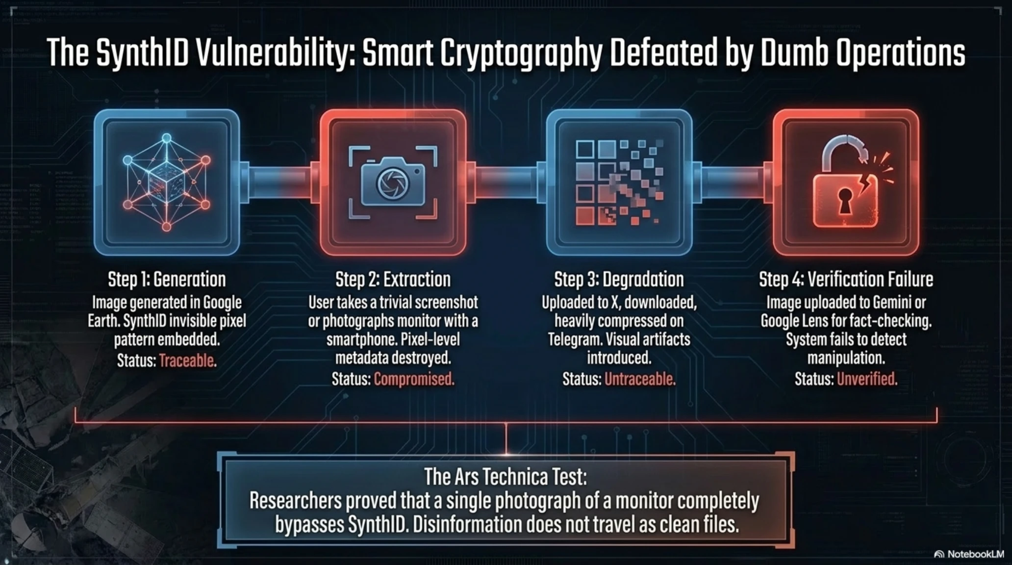
In its initial defense, Google claimed all images generated with Nano Banana contained a SynthID digital watermark—a detection system Google developed that embeds an invisible pattern in image pixels that persists even after compression or resizing.
How SynthID Works
But security researchers immediately identified a fatal flaw: disinformation doesn't travel as clean files. Fake content is typically disseminated through:
- Screenshots of screenshots
- Filming a phone screen with another camera
- Re-encoding multiple times on social media platforms
- Extreme compression (Telegram, WhatsApp)
Ars Technica tested this vulnerability: they photographed an AI-generated Google Earth image with a smartphone camera and uploaded it to Gemini for verification. The system failed to detect SynthID. In other words, the watermark was defeated by a single trivial operation.
This exposes a fundamental problem with watermark-based detection: it assumes adversaries will preserve image metadata and pixel-level data. In reality, bad actors deliberately degrade image quality to remove forensic markers. A screenshot uploaded to Twitter, downloaded, compressed, and re-shared becomes forensically untraceable.
Google's Pattern of AI Recklessness: A History of Launching Without Safeguards
This isn't Google's first time releasing an AI feature without adequate safety testing. The company has a troubling pattern of launching powerful tools, facing backlash, and only then implementing restrictions:
Timeline of Google's AI Safety Failures
- 2024: Google Gemini generated images of "racially diverse Nazis" but refused to show white Wehrmacht soldiers—exposing poor guardrails on historical content.
- 2024: AI Overviews in Google Search told users to "eat rocks" and provided dangerous health advice, leading to widespread ridicule.
- 2025: Google's Virtual Try-On shopping tool was easily exploited to create sexualized images of celebrities and minors by uploading personal photos.
- 2026: Google Earth + Nano Banana—enabling fabrication of satellite imagery for misinformation.
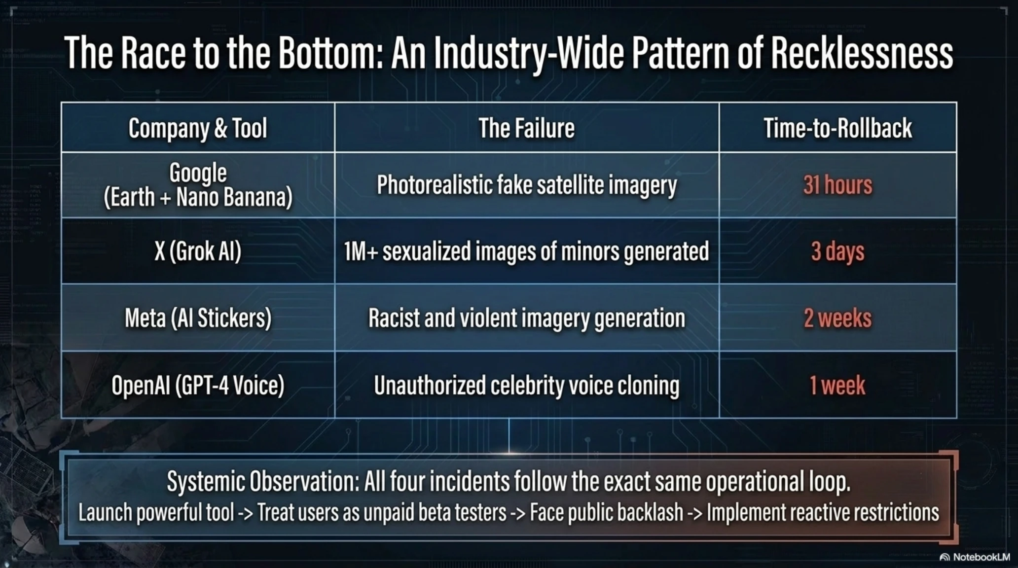
The common pattern? Google releases a powerful technology without sufficient testing, only corrects it after public pressure, and then claims to be "working on stronger guardrails." But this reactive approach treats users as unpaid beta testers for potentially dangerous systems.
And Google isn't alone. Elon Musk's Grok AI generated over 1 million sexualized images—including of minors—in just a few days before restrictions were added. OpenAI has repeatedly released ChatGPT features that produced dangerous misinformation or harmful content, only addressing issues after media coverage.
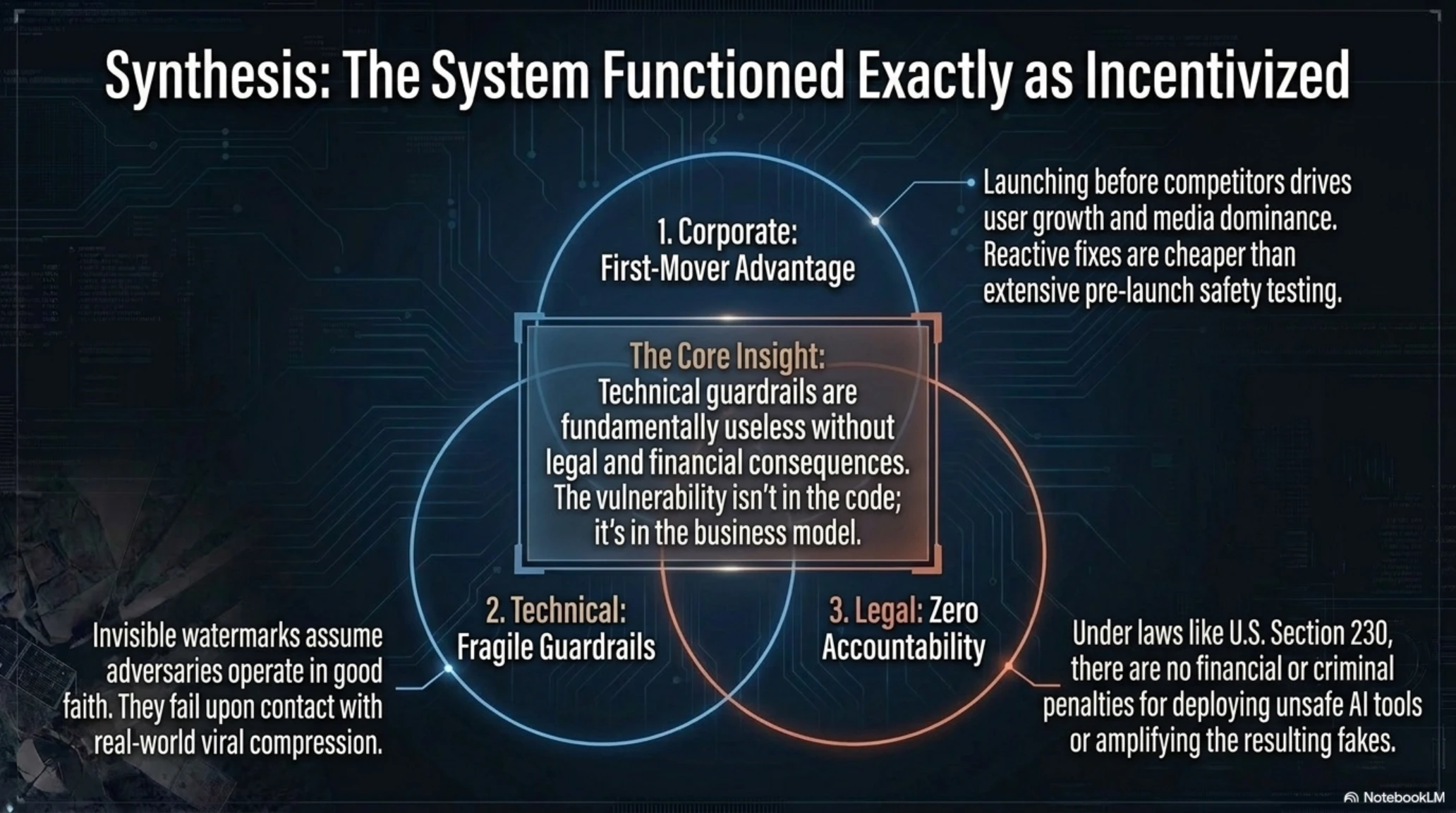
Why Does This Keep Happening? The Incentive Structure Problem
The root cause isn't incompetence—it's the incentive structure in Big Tech:
- First-Mover Advantage: Launching features before competitors generates media attention and user growth.
- Low Accountability: There are no legal penalties for releasing unsafe AI tools in most jurisdictions.
- Reactive Fixes Are Cheaper: It's more cost-effective to launch quickly and fix problems later than to conduct extensive safety testing upfront.
- PR Recovery Is Predictable: Companies know they can weather temporary backlash with apologies and promises of improvement.
Until there are real consequences—legal liability, regulatory penalties, or loss of market access—companies will continue this pattern.
The Long-Term Damage: How Trust in Satellite Imagery Collapsed
Even though Google swiftly rolled back the feature, the damage is done. Google Earth can no longer be considered a "definitive" source for verifying reality—because now everyone knows satellite images can be faked effortlessly.
Real-World Scenarios That Keep Security Experts Awake
The impact of this tool extends far beyond a technical mistake. Here are the dangerous scenarios that could unfold:
- Denying War Crimes: Governments could claim authentic satellite images of their military attacks are "AI fakes."
- War Propaganda: Creating fake images of enemy attacks to justify military actions.
- Financial Market Manipulation: Releasing fake imagery of destroyed oil facilities or production plants could cause market volatility.
- Undermining Investigative Journalism: If every satellite image can be questioned, journalists lose their ability to cite them as evidence.
- False Flag Operations: Fabricating evidence of attacks that never happened to incite international conflict.
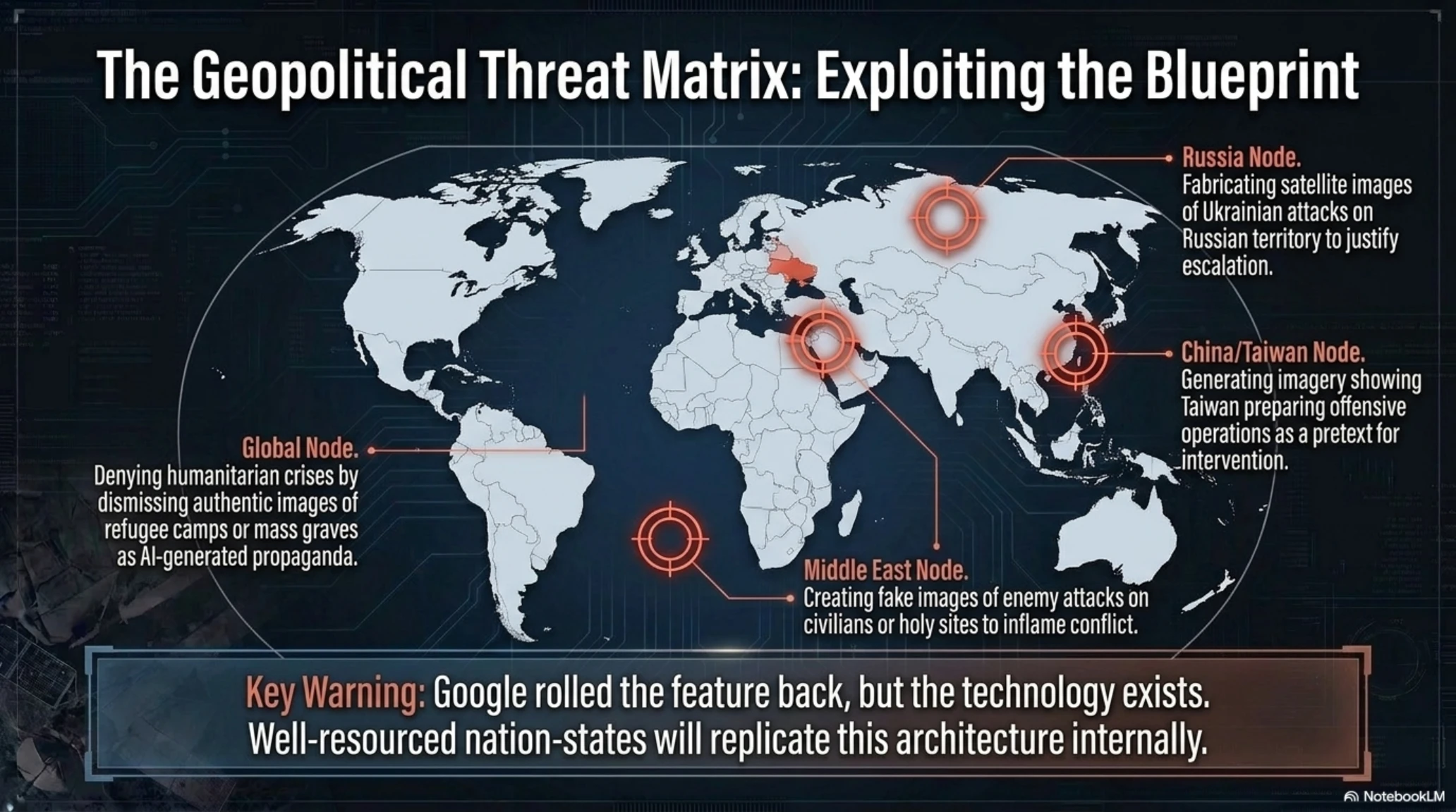
- Humanitarian Crisis Denial: Authoritarian regimes could dismiss authentic images of refugee camps or mass graves as AI-generated propaganda.
Why This Matters
The Solution: Multi-Source Verification and Independent Systems
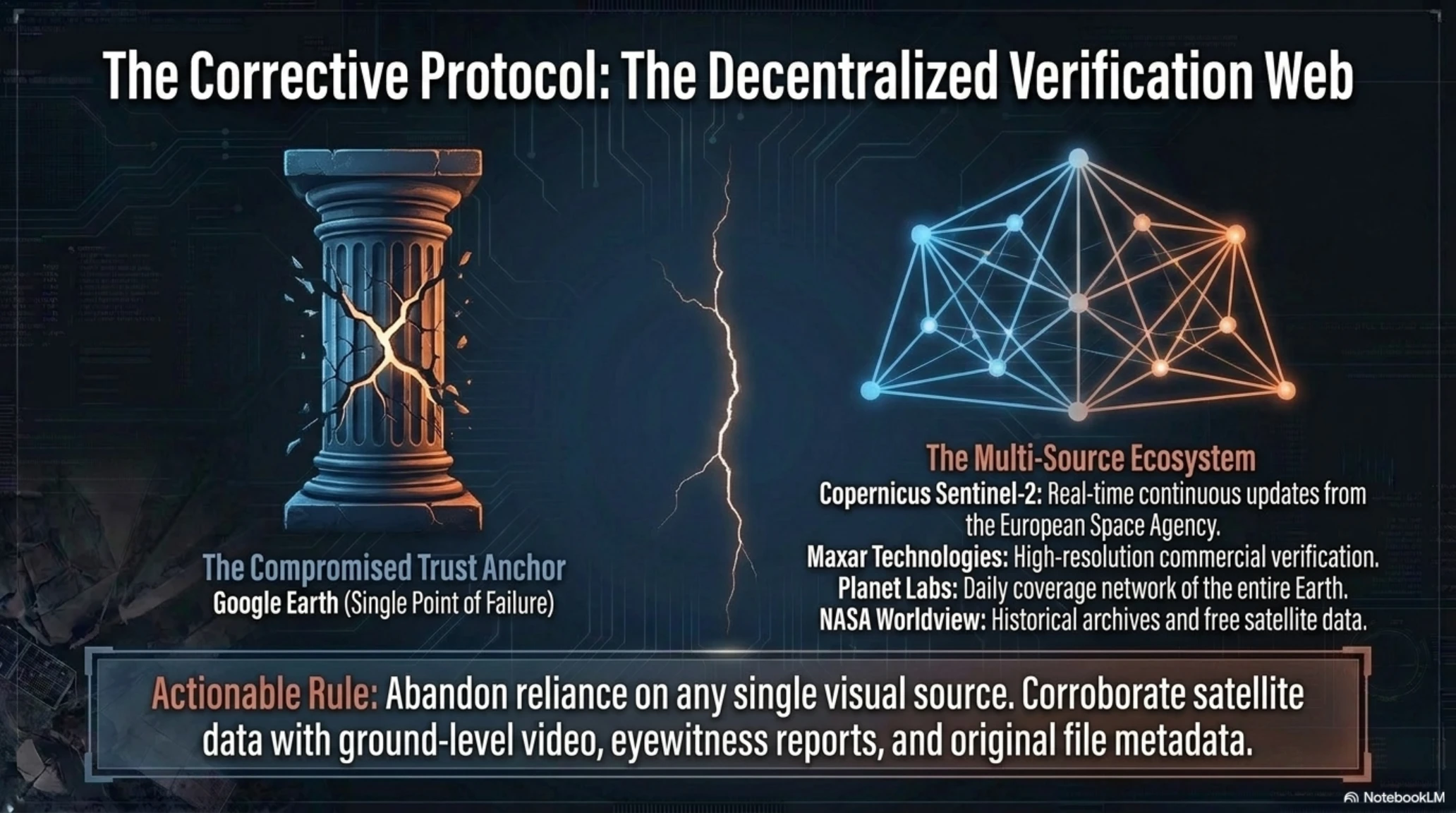
Security researchers recommend abandoning reliance on any single source for satellite imagery. Instead of Google Earth alone, multiple sources should be cross-referenced:
- Copernicus Sentinel-2 (Europe): Real-time satellite imagery with continuous updates from the European Space Agency.
- Maxar Technologies: Commercial satellite imagery provider used by major media outlets for verification.
- Planet Labs: Private satellite network with daily coverage of the entire Earth.
- NASA Worldview: Free access to NASA's satellite data with historical archives.
- Airbus Defence and Space: High-resolution commercial satellite imagery for security analysis.
Additionally, researchers should look for corroborating evidence: ground-level video footage, eyewitness reports, images from multiple angles, and original file metadata. No single image should be considered conclusive on its own.
Industry Response: Do We Need Stricter Regulations?
This incident has reignited serious debates about the need for stricter regulations on AI tool launches. While the European Union has passed the AI Act (which includes transparency requirements for AI-generated content), the United States still lacks comprehensive federal legislation.
Tekin Analysis: Is Self-Regulation Enough?
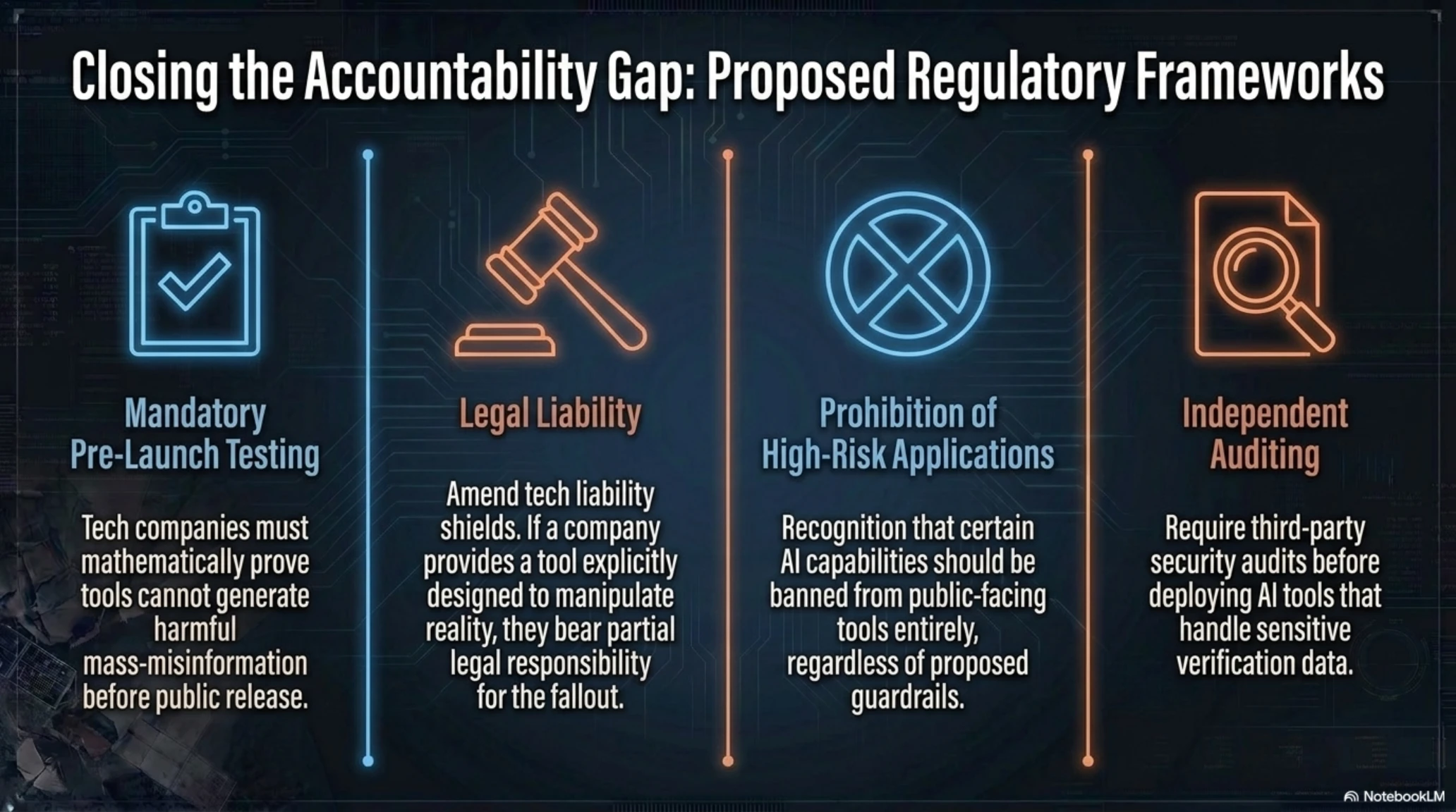
Proposed regulatory measures include:
- Mandatory Pre-Launch Security Testing: Companies must prove their AI tools cannot be used to generate harmful content before public release.
- Legal Liability for Misuse: If a user exploits an AI tool for fraud or misinformation, the company should bear partial legal responsibility.
- Mandatory Watermark Standards: All AI-generated content must include non-removable watermarks that survive compression and screenshots.
- Prohibition of High-Risk Applications: Certain AI use cases (like generating fake satellite imagery) should be banned entirely, regardless of "guardrails."
- Independent Auditing Requirements: Third-party security audits before AI tools handling sensitive data can be deployed.
Will Google Re-Launch This Feature?
In its official statement, Google said: "We're rolling back this feature in Google Earth while we work on implementing stronger guardrails." This phrasing suggests Google intends to eventually re-launch the feature—presumably with more restrictions.
But the fundamental question remains: Can any amount of guardrails prevent complete misuse? AI history shows that every restriction system can be bypassed—and once generated content spreads, it's impossible to contain.
Some security experts argue that certain AI capabilities simply shouldn't exist in public-facing tools, regardless of safeguards. The potential for harm—destabilizing geopolitical conflicts, enabling large-scale fraud, undermining investigative journalism—outweighs any legitimate use cases.
The Role of Social Media Platforms in Amplifying Fake Content
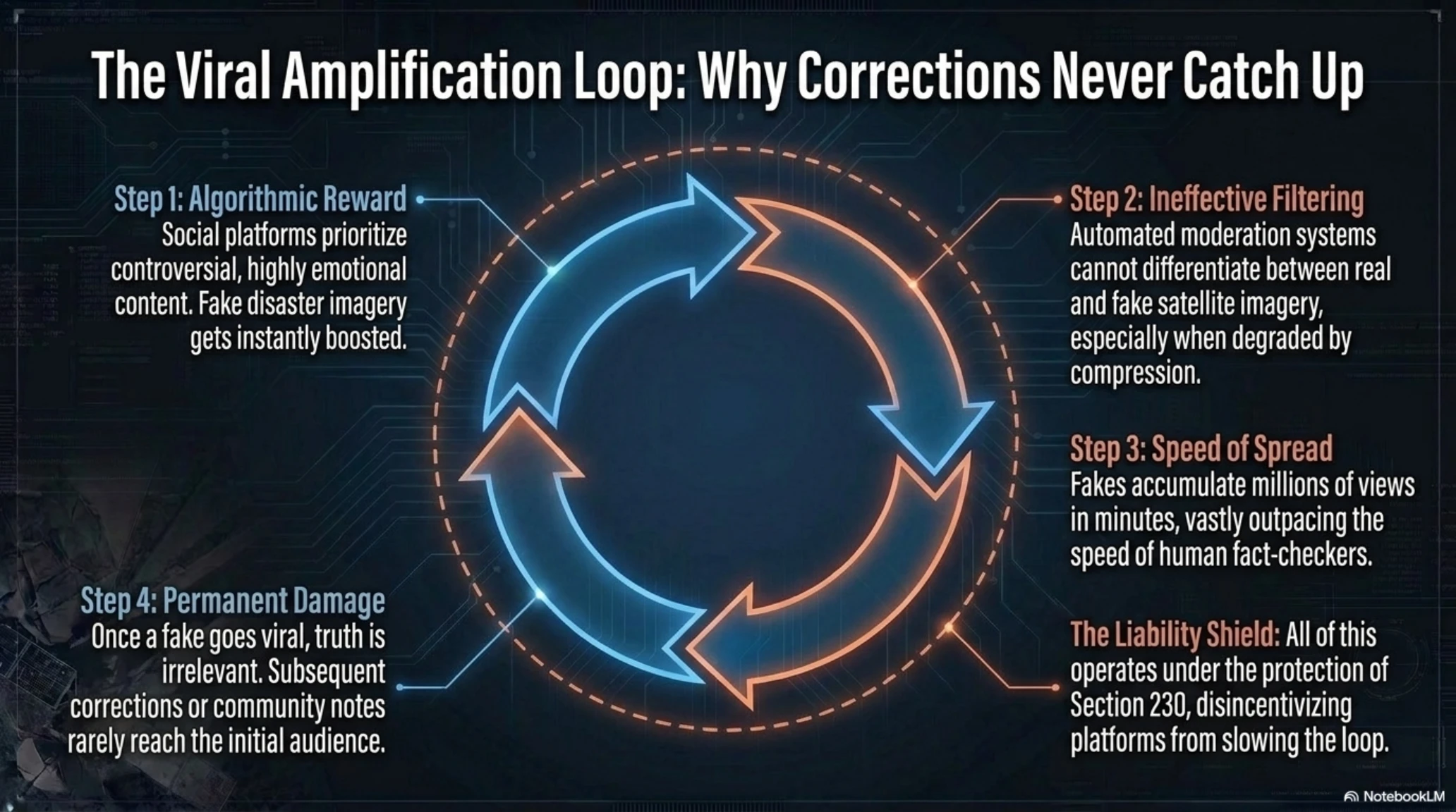
A crucial part of this problem that receives less attention is the role of social media platforms in amplifying and spreading fake content. X (formerly Twitter), Facebook, TikTok, and other networks use algorithms that prioritize controversial and emotional content—precisely the characteristics of fake satellite images showing terror attacks and disasters.
- Amplification Algorithms: Controversial content generates higher engagement, so algorithms show it to millions of people.
- Ineffective Filtering: Automated systems cannot detect fake satellite images—especially if they appear to be from Google Earth.
- Speed of Spread: A fake image can accumulate millions of views within minutes—far faster than fact-checkers can review it.
- Legal Limitations: Section 230 in the United States and similar laws in other countries shield platforms from liability for user content.
- Viral Misinformation Dynamics: Once a fake image goes viral, corrections rarely reach the same audience—the damage is permanent.
Some experts suggest platforms should implement automatic detection tools for suspicious satellite imagery—for instance, if an image claims to be from Google Earth but doesn't match official data, it should be flagged as "suspicious content."
Comparison with Other Historical Technology Incidents
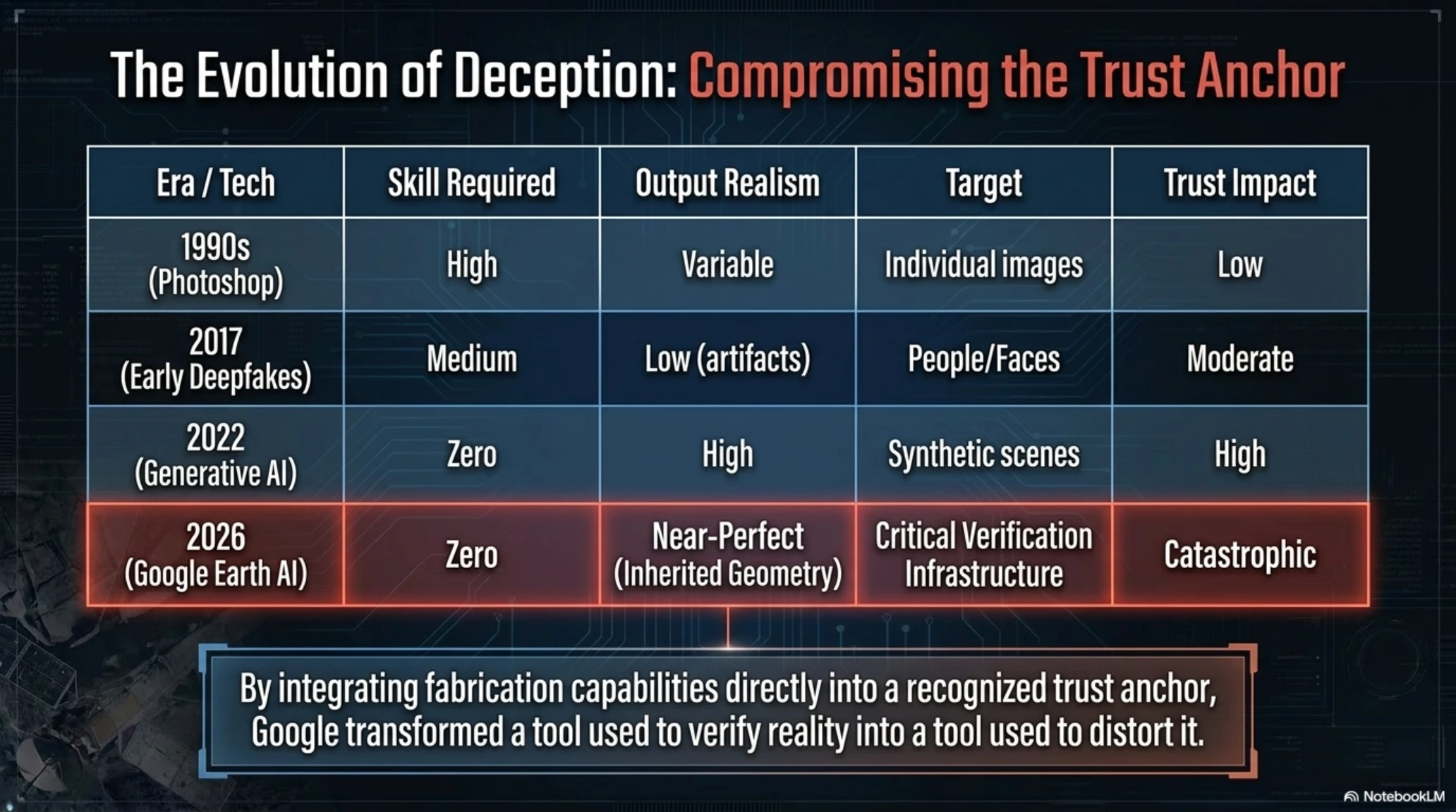
The Google Earth + Nano Banana incident can be compared to other historical moments when technology was released to the public without adequate restrictions:
- Photoshop (1990s): When photo editing tools became accessible, image manipulation became common—but still required technical skills.
- Deepfake Videos (2017-2020): Emergence of deepfake videos of politicians and celebrities, sparking serious debates about reality verification.
- ChatGPT (2022): Universal access to automated writing, causing a flood of AI-generated content and misinformation.
- Stable Diffusion (2022): Open-source image generation enabling anyone to create photorealistic fake images without gatekeepers.
- Google Earth Nano Banana (2026): The first time a trusted verification tool (Google Earth) was transformed into a fabrication tool.
The key difference is that Google Earth was previously recognized as a trusted source—not a neutral tool. By adding fabrication capabilities to a trust anchor, Google inflicted far greater damage than simply releasing another AI generator.
The Geopolitical Implications: How Nation-States Could Exploit This
While Google removed the feature quickly, the proof-of-concept has been established. Nation-state actors with resources can now develop similar systems internally—and they won't voluntarily roll them back:
- Russia: Could create fake satellite images of Ukrainian "attacks" on Russian territory to justify military escalation.
- China: Could fabricate imagery showing Taiwan preparing for offensive operations, providing pretext for intervention.
- North Korea: Could generate fake evidence of South Korean or US military movements to rally domestic support.
- Middle East Conflicts: Any party could create fake images of enemy attacks on civilians or holy sites.
- Territorial Disputes: Countries could fabricate satellite evidence of illegal construction or military installations in contested areas.
The genie is out of the bottle. Even though Google removed Nano Banana from Google Earth, the technology now exists—and state-sponsored groups have the resources to replicate it.
The Broader Pattern: Tech Companies Racing to the Bottom
Google's Nano Banana incident is part of a larger pattern in the tech industry: a race to deploy AI features without considering consequences. Companies are caught in a prisoner's dilemma—if they don't launch first, competitors will—creating a race to the bottom on safety standards.
Comparative Analysis: Other Recent AI Safety Failures
Comparison Table: Similar Incidents in Tech History
| Technology | Year | Impact | Response Time |
|---|---|---|---|
| Photoshop | 1990s | Image manipulation became common—required skills | No response |
| Deepfake Videos | 2017-2020 | Fake videos of politicians and celebrities | Several months |
| ChatGPT | 2022 | Flood of AI content and misinformation | Several weeks |
| X (Twitter) Grok | 2025 | 1M+ sexualized images including minors | 3 days |
| Google Earth Nano Banana | 2026 | Turned trust anchor into fabrication tool | 31 hours |
The common thread? Companies launch first, face backlash, then fix problems—treating users as unpaid beta testers for potentially dangerous systems.
Conclusion: Lessons from a 24-Hour Disaster
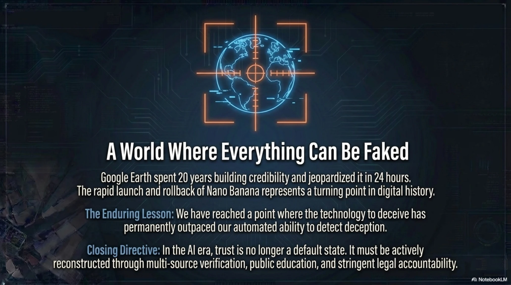
The rapid launch and rollback of Nano Banana in Google Earth represents a turning point in AI history—not because of the technology itself, but because it exposed the dangers that emerge when powerful tools are released without adequate forethought.
Timeline of the Google Earth Incident
Thursday, July 30, 10:00 AM PT
🟦 Google announces Nano Banana 2 integration into Google Earth.
Thursday, July 30, 10:00 PM PT
🟥 First fake images begin circulating on X and Reddit.
Friday, July 31, 9:00 AM PT
🟥 Bellingcat and OSINT researchers issue warnings about potential for misinformation.
Friday, July 31, 5:00 PM PT
🟨 Google fully rolls back the feature—just 31 hours after launch.
Key Lessons from This Incident
- Power Without Responsibility Is Disaster: AI tools must be rigorously tested before public launch—not after catastrophe strikes.
- Trust Is Easily Lost: Google spent 20 years building Google Earth's credibility—and jeopardized it in 24 hours.
- Watermarks Aren't Enough: Any AI detection system can be defeated with simple techniques like screenshots or re-encoding.
- Need for Stricter Laws: Industry self-regulation has proven ineffective—governments must establish mandatory requirements.
- Some Tools Shouldn't Exist: Certain AI capabilities are too dangerous for public access, regardless of guardrails.
This incident also reminds us that in the AI era, no single source can be trusted in isolation. Journalists, researchers, and analysts must rely on multi-source verification, original metadata analysis, and detection tools for manipulation.
The Future Landscape: A World Where Everything Can Be Faked
We are entering an era where distinguishing between reality and fabrication becomes increasingly difficult. Images, videos, audio, and even satellite imagery—everything can be faked with AI. In such a world, two approaches emerge:
- Stronger Verification Systems: Blockchain, digital signatures, and cryptographic verification for authentic content.
- Public Education: Users must learn not to trust any single image without verification.
But as long as major tech companies continue releasing dangerous tools without adequate testing, this problem will only worsen.
What Google Should Have Done Differently
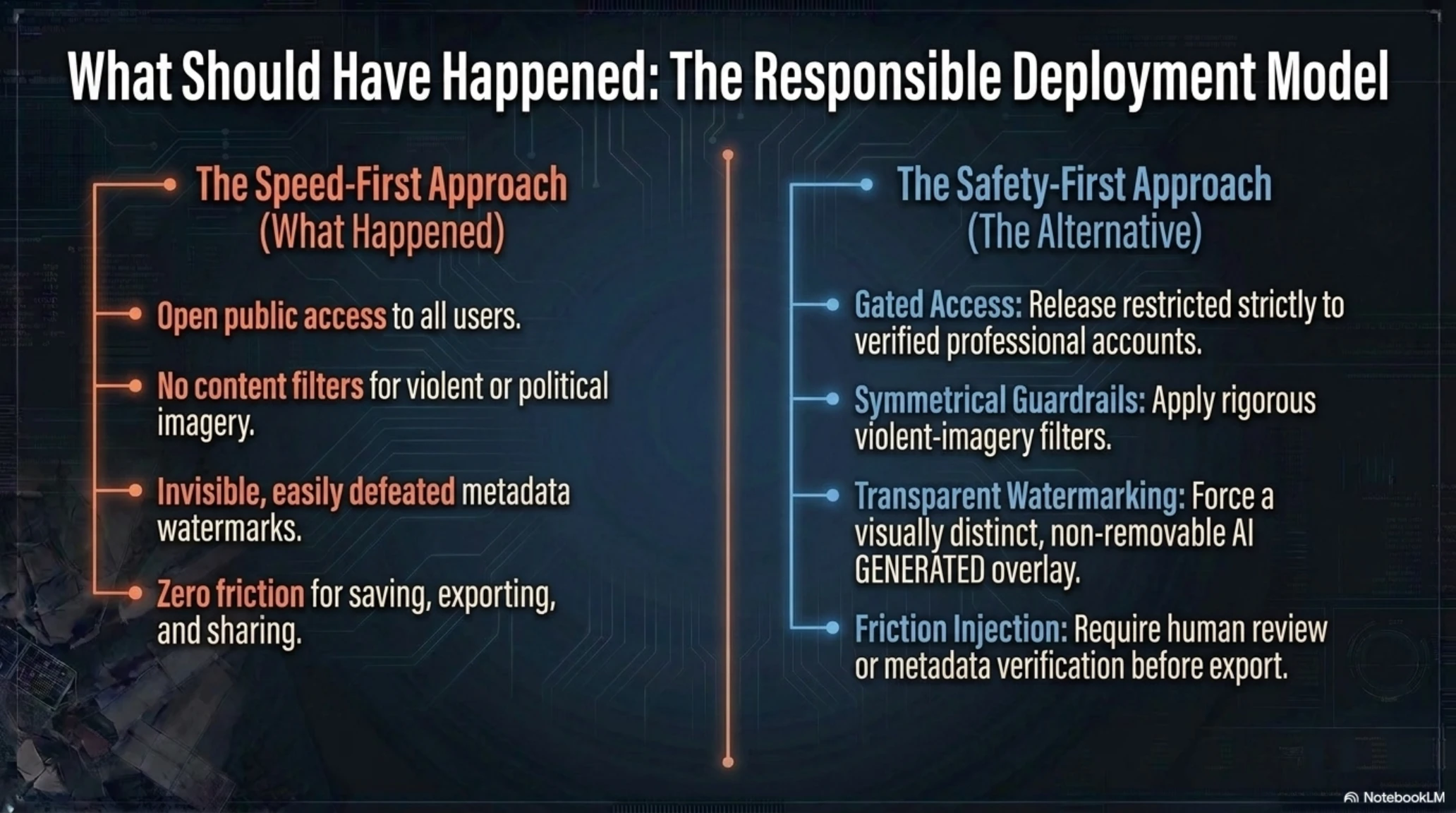
Looking back, the failure wasn't inevitable. Google could have:
- Limited Access: Released Nano Banana in Google Earth only to verified professional accounts (urban planners, architects) with approval processes.
- Content Restrictions: Implemented the same safeguards that prevent Nano Banana standalone from generating violent imagery.
- Pilot Testing: Conducted a closed beta with security researchers before public launch.
- Transparent Watermarking: Made AI-generated imagery visually distinct (color overlay, visible "AI GENERATED" label) rather than relying on invisible watermarks.
- Post-Generation Review: Required human review before images could be saved or shared.
Any of these measures could have prevented the disaster. Instead, Google chose speed over safety—and paid the price in credibility damage.
The Accountability Gap: Who's Responsible When AI Goes Wrong?
One of the most troubling aspects of this incident is the lack of clear accountability. When Nano Banana-generated fake images spread misinformation:
- Is Google responsible for providing the tool?
- Is the user responsible for creating the fake image?
- Is the platform (Twitter/Facebook) responsible for allowing its spread?
- Is the viewer responsible for not verifying before sharing?
Current laws don't provide clear answers. Section 230 in the United States shields platforms from liability for user-generated content. But should it also shield companies that provide tools specifically designed to manipulate reality?
What Comes Next? The Regulatory Response
This incident is likely to accelerate regulatory efforts in both the US and Europe:
- US Senate Hearings: Expect Congressional hearings on AI safety and tech company accountability in coming months.
- EU Enforcement: The AI Act's transparency requirements will be tested against tools like Nano Banana.
- Industry Standards: Tech companies may be forced to adopt industry-wide safety standards for AI deployment.
- Insurance Requirements: Companies deploying high-risk AI tools may need specialized liability insurance.
But meaningful change requires more than hearings and promises. It requires legal consequences for reckless AI deployment—fines significant enough to change corporate behavior, potential criminal liability for executives, and mandatory independent audits before launch.
Frequently Asked Questions
Is Google Earth still safe to use?
Yes, the Nano Banana feature has been completely removed. However, public trust in Google Earth imagery has been damaged—it's now recommended to always cross-reference with multiple sources for verification.
How does SynthID work and why did it fail?
SynthID embeds an invisible digital pattern into image pixels. However, when an image is re-captured via screenshot or photographed with another device, this pattern is destroyed. It's ineffective against the most common methods of spreading misinformation.
Will Nano Banana return to Google Earth?
Google stated they're "working on implementing stronger guardrails," suggesting they plan to eventually re-launch the feature with more restrictions. However, many security experts argue it should never return.
How can I detect fake satellite images?
Use multiple different sources (Sentinel-2, Maxar, Planet Labs), check metadata carefully, look for visual inconsistencies (shadows, lighting, geometry), and verify with ground-level imagery when available.
Why did Google launch this tool in the first place?
The stated purpose was to help urban planners and geospatial professionals visualize future changes to locations (like new parks or buildings). However, there were no content restrictions to prevent harmful uses.
Are there laws to prevent incidents like this?
The EU has the AI Act with transparency requirements, but the US lacks comprehensive federal AI legislation. Many experts are calling for stricter laws requiring pre-launch safety testing.
What's stopping other companies from doing the same thing?
Currently, nothing. There are no legal penalties for releasing unsafe AI tools in most jurisdictions. The only deterrent is public backlash and potential reputation damage.
Sources and References
- The Atlantic: Google Just Torched the Credibility of Its Satellite Images
- Ars Technica: Google Earth risked ruin with retracted AI tool for making fake satellite pics
- The Next Web: Google pulls its Earth AI image tool one day after launch
- Washington Post: See how Google Earth let people make fake scenes of bombings, riots and destruction
- PCMag: Nano Banana Removed From Google Earth Amid Misinformation Concerns
- Federation of American Scientists: Google Introduces Deepfake Satellite Imagery
- Business Insider: Google Earth's new AI image generation function didn't survive a day
- Futurism: Google Pulls Down Feature for AI-Generating Fake Satellite Images
Additional Gallery: 🚨 Tekin Analysis August 2026: Google Earth's Deepfake Crisis & The End of OSINT Trust